What you see from the summit
The full 360-degree view from Punta Alta, computed from the elevation model and labelled with the names of the peaks you can see. Drag the image sideways; the slider hides the far distance.
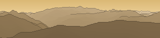
From up here 150 named peaks are in sight. The highest: Tuca d'Aneto / Maladeta de Corones, 3404 m. The most distant: Pic dels Vidals, 53.6 km away.
The highest peaks in view
- Tuca d'Aneto / Maladeta de Corones
- Tuca de Posets
- Pico Maldito
- Punta de Treserols / Monte Perdido
- Punta Llardaneta o Pico Espadas
- Tuca de la Maladeta
- Tuca de Corones
- Tuca de Tempestats / Tuca Gran de Llosás
- Tuca d'el Cabo de la Tartera
- Pico Plan de Marmorés / Marboré
- Pic Perdiguère / Tuca de'l Perdiguero
- Tuca d'el Cap de la Vall
📏Elevation2735 m
⛰️Categorytwo-thousander
📍Position42.53696, 0.34502
🗺️Planningfree
About Punta Alta
Punta Alta is a 2735 m two-thousander in the Alps. The view reaches as far as Tuca d'Aneto / Maladeta de Corones at 3404 m. Plan your route to Punta Alta free of charge with Peakflow: real paths, elevation profile, weather and an offline map.
Where the peak stands
Plan your tour with Peakflow
Routes on real paths, a colour elevation profile, weather windows, water sources, snow cover and GPX export – free, no ads, no subscription.
Plan your tour to Punta Alta →Or download the app: