Das sehen Sie vom Gipfel
Der Rundblick von der la Serra über volle 360 Grad, aus dem Höhenmodell gerechnet und mit den Namen der sichtbaren Gipfel beschriftet. Ziehen Sie das Bild zur Seite, der Regler blendet die Ferne aus.
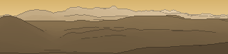
Von hier aus sind 153 benannte Gipfel zu sehen. Der höchste: Corno Grande - Vetta Occidentale, 2912 m. Der fernste: Monte Siella, 54,2 km Luftlinie.
Die höchsten Gipfel im Blickfeld
- Corno Grande - Vetta Occidentale
- Corno Piccolo
- Pizzo d'Intermesoli
- Monte Corvo
- Monte Camicia
- Monte Prena
- Cima Ovest del Monte Corvo
- Monte Aquila
- Monte Velino
- Vetta Settentrionale d'Intermesoli
Was in welcher Richtung zu sehen ist
Monte Pozzoni (1903 m, 42,7 km), Monte Nuria (1888 m, 10,1 km), Colle della Fungara (1887 m, 10 km), Colle di Mezzo (1873 m, 13,9 km), Monte Laghetto (1836 m, 41,5 km), Monte Iacci (1826 m, 26,9 km), Monte Boragine (1824 m, 34,6 km), Monte Giano (1817 m, 17,4 km) und 10 weitere.
Corno Grande - Vetta Occidentale (2912 m, 41,7 km), Corno Piccolo (2655 m, 41,9 km), Pizzo d'Intermesoli (2635 m, 39,2 km), Monte Corvo (2623 m, 37,4 km), Cima Ovest del Monte Corvo (2533 m, 36,9 km), Monte Aquila (2494 m, 41,2 km), Vetta Settentrionale d'Intermesoli (2483 m, 39,6 km), Monte Gorzano (2458 m, 43,8 km) und 18 weitere.
Monte Camicia (2564 m, 51,6 km), Monte Prena (2561 m, 49 km), Monte Ocre (2208 m, 26 km), Monte Cefalone (2142 m, 25,4 km), Cima di Fossa Palomba (2120 m, 24,6 km), Cima dei Monti di Bagno (2073 m, 24,7 km), Monte La Torricella (2071 m, 21,5 km), Monte Orsello (2043 m, 19,4 km) und 20 weitere.
Monte Velino (2486 m, 25,1 km), Cima Avezzano (2378 m, 25,4 km), Punta Trento (2243 m, 25,4 km), Costone Occidentale (2239 m, 22,8 km), Murolungo (2184 m, 20,6 km), Monte Viglio (2156 m, 47,9 km), Monte Morrone (2141 m, 18,6 km), Cima nord del Passo del Puzzillo (2131 m, 22,8 km) und 16 weitere.
Monte Cotento (2015 m, 43,7 km), Peschio della Cornacchia (1983 m, 52,3 km), Monte Tarino (1961 m, 40,5 km), Monte Autore (1855 m, 35,9 km), Monte Tarinello (1844 m, 39,4 km), Cima di Vallevona (1818 m, 29,6 km), La Torretta (1799 m, 28,4 km), Colle della Tagliata (1668 m, 36,2 km) und 13 weitere.
Monte Navegna (1508 m, 11,7 km), Monte Cervia (1431 m, 14,3 km), Monte Pellecchia (1370 m, 29 km), Pizzo Pellecchia (1331 m, 29,8 km), Monte Filone (1329 m, 12,4 km), Colle Valle del Lago (1280 m, 28,4 km), Monte Faito (1224 m, 17,9 km), Monte S. Giovanni (1016 m, 16,1 km) und 6 weitere.
Monte Aquilone (1320 m, 11,6 km), Monte Pizzuto (1288 m, 34,1 km), Tancia - vetta meridionale (1281 m, 32,3 km), Colle Ettore (1272 m, 9,6 km), Monte Macchia Gelata (1258 m, 34,6 km), Monte Porco Morto (1258 m, 35,8 km), Monte Alto (1245 m, 34,1 km), Autta (1215 m, 12,4 km) und 8 weitere.
Monte Nurietta (1884 m, 8,3 km), Monte Moro (1524 m, 5 km), Monte le Rocchette (1461 m, 5 km), Monte Lupara (1231 m, 39 km), Monte Macchia di Mezzo (1215 m, 38 km), Monte Cingiara (783 m, 16,3 km).
Über die la Serra
Die la Serra ist ein 1607 m hoher Alpengipfel in den Alpen, in der Nähe von Castellaccio, la Serra, la Serra. Plane deine Tour zur la Serra kostenlos mit Peakflow – auf echten Wegen, mit Höhenprofil, Wetter und Offline-Karte.
La Serra war eine Talsperre oberhalb von Zernez im Engadin im Schweizer Kanton Graubünden. Die Ruinen liegen südöstlich des Dorfes an der Passstrasse.
Quelle der Beschreibung: Wikipedia (CC BY-SA), via Peakflow.
Wo der Gipfel steht
Gipfel in der Nähe

Häufige Fragen zur la Serra
Welche Berge sieht man von der la Serra?
Vom Gipfel aus sind 153 benannte Gipfel zu sehen. Die höchsten davon: Corno Grande - Vetta Occidentale (2912 m, 41,7 km), Corno Piccolo (2655 m, 41,9 km), Pizzo d'Intermesoli (2635 m, 39,2 km), Monte Corvo (2623 m, 37,4 km), Monte Camicia (2564 m, 51,6 km). Der fernste sichtbare Gipfel ist Monte Siella in 54,2 km Luftlinie. Peakflow berechnet die Sicht aus dem Geländemodell und beschriftet sie im 360°-Rundblick.
Wie hoch ist die la Serra?
Die la Serra ist 1607 m hoch und liegt in den Alpen. In der Umgebung liegen Castellaccio (1355 m), la Serra (1599 m), la Serra (1361 m).
Tour planen mit Peakflow
Route auf echten Wegen, farbiges Höhenprofil, Wetterfenster, Wasserquellen, Schneelage und GPX-Export – kostenlos, ohne Werbung, ohne Abo.
Jetzt Tour zur la Serra planen →
