Das sehen Sie vom Gipfel
Der Rundblick vom Monte Campomolon über volle 360 Grad, aus dem Höhenmodell gerechnet und mit den Namen der sichtbaren Gipfel beschriftet. Ziehen Sie das Bild zur Seite, der Regler blendet die Ferne aus.
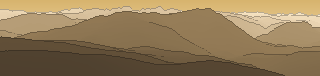
Von hier aus sind 143 benannte Gipfel zu sehen. Der höchste: Cima Brenta, 3151 m. Der fernste: Roen, 54,6 km Luftlinie.
Die höchsten Gipfel im Blickfeld
- Cima Brenta
- Cima Tosa
- Cima Bassa d'Ambiez
- Torre di Brenta
- Cima Falkner
- Cima di Vallon
- Cima Prato Fiorito
- Cima d'Asta
- Cima Margherita
- Cima della Banca
Was in welcher Richtung zu sehen ist
Monte Croce (2489 m, 33,9 km), Ziolera (2481 m, 35,7 km), Schliverai Spitz (2432 m, 32,1 km), Sasso Rotto (2394 m, 29,4 km), Pala di Stramaiolo - Mitreck (2362 m, 31,6 km), Fravort (2347 m, 23,1 km), Hoabonti (2334 m, 25,4 km), Cimon di Pontara (2163 m, 31 km) und 9 weitere.
Cima d'Asta (2847 m, 41,9 km), Cima della Banca (2729 m, 41,7 km), Cimon de le Sute (2616 m, 42,2 km), Cima delle Buse (2574 m, 38,5 km), Cima Litegosa (2549 m, 44,5 km), Castel di Bombasel (2535 m, 42,5 km), Coltorondo (2530 m, 50,6 km), Monte Cengello (2439 m, 38 km) und 19 weitere.
Monte Fior (1824 m, 24,9 km), Monte Grappa (1776 m, 39,9 km), Monte Castelgomberto (1771 m, 25,1 km), Monte Cimon (1768 m, 20,8 km), Cima di Campolongo (1720 m, 8,2 km), Spitz di Tonezza (1694 m, 2,7 km), Col dell'Orso (1677 m, 42,1 km), Monte Solarolo (1672 m, 43 km) und 13 weitere.
Cima Favaro (1433 m, 15,5 km), Monte Carriola (1368 m, 15,1 km), Monte Cengio (1354 m, 11,1 km), Monte Ceramella (1342 m, 14,9 km), Cima Summano (1296 m, 15,1 km), Monte Tormeno (1292 m, 3,6 km), Pilastro D'Autunno (1282 m, 3,4 km), Monte Costo (1221 m, 10,1 km) und 4 weitere.
Cima Campo d'Avanti (1691 m, 23,3 km), Cima del Mesole (1672 m, 23,6 km), Monte Campetto (1662 m, 23,5 km), Torre Vaccaresse (1458 m, 10,3 km), Monte Spin (1410 m, 11,2 km), Monte Rozzo Covole (1252 m, 11,9 km), Cima la Locchetta (804 m, 17,9 km).
Cima Carega (2259 m, 20,5 km), Cima Palon (2232 m, 12,3 km), Cima del Cherlong (2209 m, 20,4 km), Denti del Cogolo (2199 m, 12,6 km), Roite (2144 m, 12 km), Torre Mosca (2142 m, 20 km), Col Santino (2127 m, 10,9 km), Col Santo (2112 m, 11,3 km) und 16 weitere.
Monte Altissimo di Nago (2079 m, 31,5 km), Monte Stivo (2054 m, 25,4 km), Doss dell'Anziana (2002 m, 11,5 km), Monte Caplone (1976 m, 50,5 km), Monte Tremalzo (1973 m, 45,5 km), Cima Valbona (1864 m, 1,1 km), Monte Lavino (1837 m, 48,3 km), Costa D'Agra (1822 m, 3,3 km) und 4 weitere.
Cima Brenta (3151 m, 45,2 km), Cima Tosa (3136 m, 44,9 km), Cima Bassa d'Ambiez (3017 m, 44,6 km), Torre di Brenta (3014 m, 44,4 km), Cima Falkner (2990 m, 46,1 km), Cima di Vallon (2969 m, 44,9 km), Cima Prato Fiorito (2900 m, 44,4 km), Cima Margherita (2845 m, 44,4 km) und 15 weitere.
Über den Monte Campomolon
Der Monte Campomolon ist ein 1853 m hoher Alpengipfel in den Alpen, in der Nähe von Monte Cimone, Monte Buso, Becco di Filadonna. Der markierte Weg zum Gipfel hat die SAC-Schwierigkeit T1 Wandern. Plane deine Tour zum Monte Campomolon kostenlos mit Peakflow – auf echten Wegen, mit Höhenprofil, Wetter und Offline-Karte.
Das (unvollendete) Forte Campomolon war als Teil der italienischen Befestigungskette vor der Höhe der Sieben Gemeinden in der Provinz Vicenza vorgesehen. (Quelle: Wikipedia)
Quelle der Beschreibung: Wikipedia (CC BY-SA), via Peakflow.
Wo der Gipfel steht
Gipfel in der Nähe

Häufige Fragen zum Monte Campomolon
Welche Berge sieht man vom Monte Campomolon?
Vom Gipfel aus sind 143 benannte Gipfel zu sehen. Die höchsten davon: Cima Brenta (3151 m, 45,2 km), Cima Tosa (3136 m, 44,9 km), Cima Bassa d'Ambiez (3017 m, 44,6 km), Torre di Brenta (3014 m, 44,4 km), Cima Falkner (2990 m, 46,1 km). Der fernste sichtbare Gipfel ist Roen in 54,6 km Luftlinie. Peakflow berechnet die Sicht aus dem Geländemodell und beschriftet sie im 360°-Rundblick.
Wie hoch ist der Monte Campomolon?
Der Monte Campomolon ist 1853 m hoch und liegt in den Alpen. In der Umgebung liegen Monte Cimone (1226 m), Monte Buso (2080 m), Becco di Filadonna (2150 m).
Wie schwierig ist der Aufstieg zum Monte Campomolon?
Der markierte Weg zum Monte Campomolon ist nach der SAC-Bergwanderskala mit T1 Wandern bewertet. Das ist ein einfacher Wanderweg.
Tour planen mit Peakflow
Route auf echten Wegen, farbiges Höhenprofil, Wetterfenster, Wasserquellen, Schneelage und GPX-Export – kostenlos, ohne Werbung, ohne Abo.
Jetzt Tour zum Monte Campomolon planen →