Das sehen Sie vom Gipfel
Der Rundblick vom Monte Guardia über volle 360 Grad, aus dem Höhenmodell gerechnet und mit den Namen der sichtbaren Gipfel beschriftet. Ziehen Sie das Bild zur Seite, der Regler blendet die Ferne aus.
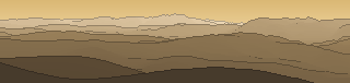
Von hier aus sind 142 benannte Gipfel zu sehen. Der höchste: Monte Velino, 2486 m. Der fernste: Colle dello Stubbio, 54,2 km Luftlinie.
Die höchsten Gipfel im Blickfeld
- Monte Velino
- Monte di Sevice
- Costone
- Punta Trento
- Monte Magnola
- Monte Ocre
- Murolungo
- Monte Puzzillo
- Monte Viglio
- Monte Morrone
Was in welcher Richtung zu sehen ist
Cima d'Arme (1675 m, 49,4 km), Collelungo (1652 m, 53,7 km), Monte Pellecchia (1370 m, 4 km), Cima Fidene (1361 m, 3,4 km), Monte Tancia (1292 m, 30,1 km), Monte Pizzuto (1288 m, 31,4 km), Monte Lupara (1231 m, 44,5 km), Colle Pietropaolo (1217 m, 5,3 km) und 10 weitere.
Monte Ocre (2208 m, 53,2 km), Monte Orsello (2043 m, 46,6 km), Monte Cava (2000 m, 40,6 km), Monte Calvo (1898 m, 46 km), Colle di Mezzo (1873 m, 45,5 km), Colle Acetoni (1806 m, 41 km), Colle Peschiarolo (1749 m, 41,1 km), la Piaggia (1637 m, 41,9 km) und 16 weitere.
Monte Velino (2486 m, 44,5 km), Monte di Sevice (2355 m, 43,8 km), Costone (2271 m, 45,9 km), Punta Trento (2243 m, 46,8 km), Monte Magnola (2220 m, 50,7 km), Murolungo (2184 m, 42,2 km), Monte Puzzillo (2174 m, 47,1 km), Monte Morrone (2141 m, 41,5 km) und 23 weitere.
Monte Viglio (2156 m, 47,7 km), Monte Crepacuore (1997 m, 48,6 km), Peschio della Cornacchia (1983 m, 49,1 km), Cima di Monna Moschino (1962 m, 47,4 km), Monte La Monna (1952 m, 51,8 km), Monte Vermicano (1948 m, 48,6 km), Monte Autore (1855 m, 31,5 km), Monte Calvo (1591 m, 26,6 km) und 21 weitere.
Monte Lupone (1378 m, 48,4 km), Monte Guadagnolo (1218 m, 18,5 km), Monte Rinsaturo (1166 m, 45,9 km), Monte dei Briganti (1127 m, 46,9 km), Monte Formello (1045 m, 22 km), Monte Follettoso (1006 m, 3,1 km), Colle Zappacenere (977 m, 14,9 km), Colle degli Aselli (963 m, 1,8 km) und 12 weitere.
Collacchi Cipenne (1087 m, 1,8 km), Colle del Tesoro (1074 m, 3,7 km).
Monte Gennaro (1272 m, 4 km), Monte Zappi (1148 m, 4,5 km), Monte Morrone della Croce (1052 m, 4,8 km), Colle dei Cerracchi (1024 m, 1,7 km), Monte Rocca Romana (612 m, 52,4 km), Monte Calvi (583 m, 53,2 km).
Monte Cosce (1114 m, 41,8 km), Monte San Pancrazio (1027 m, 45,6 km), Colle del Castagnaro (930 m, 3,4 km), Colle le Mollie (866 m, 3,6 km), Colle Turisso (848 m, 3,2 km), Colle Termine (807 m, 6 km), Monte Calvario (779 m, 7,7 km), Colle le Ciammarughe (758 m, 5,6 km) und 4 weitere.
Über den Monte Guardia
Der Monte Guardia ist ein 1184 m hoher Alpengipfel in den Alpen. Plane deine Tour zum Monte Guardia kostenlos mit Peakflow – auf echten Wegen, mit Höhenprofil, Wetter und Offline-Karte.
Ponza ist eine der Pontinischen Inseln im Tyrrhenischen Meer rund 50 km südwestlich von Terracina. Sie gehört zur italienischen Region Latium und ist Teil der Gemeinde Ponza in der Provinz Latina.
Quelle der Beschreibung: Wikipedia (CC BY-SA), via Peakflow.
Wo der Gipfel steht
Häufige Fragen zum Monte Guardia
Welche Berge sieht man vom Monte Guardia?
Vom Gipfel aus sind 142 benannte Gipfel zu sehen. Die höchsten davon: Monte Velino (2486 m, 44,5 km), Monte di Sevice (2355 m, 43,8 km), Costone (2271 m, 45,9 km), Punta Trento (2243 m, 46,8 km), Monte Magnola (2220 m, 50,7 km). Der fernste sichtbare Gipfel ist Colle dello Stubbio in 54,2 km Luftlinie. Peakflow berechnet die Sicht aus dem Geländemodell und beschriftet sie im 360°-Rundblick.
Wie hoch ist der Monte Guardia?
Der Monte Guardia ist 1184 m hoch und liegt in den Alpen.
Tour planen mit Peakflow
Route auf echten Wegen, farbiges Höhenprofil, Wetterfenster, Wasserquellen, Schneelage und GPX-Export – kostenlos, ohne Werbung, ohne Abo.
Jetzt Tour zum Monte Guardia planen →
