Das sehen Sie vom Gipfel
Der Rundblick vom Monte Taburno über volle 360 Grad, aus dem Höhenmodell gerechnet und mit den Namen der sichtbaren Gipfel beschriftet. Ziehen Sie das Bild zur Seite, der Regler blendet die Ferne aus.
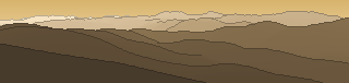
Von hier aus sind 118 benannte Gipfel zu sehen. Der höchste: Monte Miletto, 2050 m. Der fernste: Monte Cervarolo di Bagnoli, 54,7 km Luftlinie.
Die höchsten Gipfel im Blickfeld
- Monte Miletto
- Colle Tamburo
- la Gallinola
- Monte Mutria
- .
- Monte Terminio
- Monte Crocetta
- Monte Raiamagra
- Monte Pastonico
- Colle del Caprio
Was in welcher Richtung zu sehen ist
la Gallinola (1923 m, 40,9 km), Monte Mutria (1823 m, 33,1 km), . (1816 m, 33,2 km), Monte Pastonico (1640 m, 32,9 km), Monte Porco (1605 m, 32,8 km), Il Palumbaro (1552 m, 32,2 km), Monte Moschiaturo (1471 m, 31,4 km), Camposauro (1390 m, 8,3 km) und 17 weitere.
Monte Saraceno (1145 m, 54,3 km), Difesa (1060 m, 52,2 km), Monte Vento (1056 m, 52,6 km), Monte San Vito (1015 m, 53,3 km), Monte Stillo (1010 m, 53,8 km), Monte San Marco il Telegrafo (1007 m, 38,7 km), Monte del Forno (991 m, 53,5 km), Paolina della Riccia (985 m, 47,4 km) und 6 weitere.
Pizzo - Trevico (1080 m, 52,9 km), Monte Cerreto (1028 m, 53,3 km), Pizzo - Baronia (990 m, 53,8 km), Monte Calvello (921 m, 54,2 km).
Monte Terminio (1806 m, 39,8 km), Monte Raiamagra (1667 m, 53,1 km), Monte Mai (1607 m, 40,5 km), M. Acerone di Avella ( Toppole ) (1598 m, 14,7 km), Cima Valle di Piedimonte (1582 m, 14 km), Monte Partenio (1573 m, 18,4 km), Monte Cervarolo di Bagnoli (1563 m, 54,7 km), Colla di Basso (1526 m, 38,3 km) und 15 weitere.
Porca delle Pere (1485 m, 13,2 km), Molare (1444 m, 50,2 km), Croce di Puntone (1425 m, 12,8 km), Monte Ciesco Alto (1357 m, 12 km), Monte Cerreto (1313 m, 44,5 km), Tuppo Alto (1250 m, 11,5 km), Monte Cervigliano (1203 m, 47,8 km), Monte Finestra (1145 m, 45,2 km) und 15 weitere.
Vesuvio (1281 m, 33,6 km), Punta del Nasone (1131 m, 32 km), Cognoli di Trocchia (961 m, 32,9 km), Cognoli di Levante (942 m, 32,2 km), Ciglio Pedalino (870 m, 9,3 km), Monte Orni (832 m, 10,1 km), Monte Vorrano (797 m, 11,6 km), Monte Tairano (768 m, 7,1 km) und 4 weitere.
Monte Burrano (765 m, 11,4 km).
Monte Miletto (2050 m, 44,2 km), Colle Tamburo (1982 m, 45,4 km), Monte Crocetta (1735 m, 42,1 km), Colle del Caprio (1611 m, 46,8 km), Monte Ianara (1575 m, 45,1 km), Monte Valle Diamante (1571 m, 48 km), Monte Ruzzo (1563 m, 45,3 km), Monte Cappello (1406 m, 47,7 km) und 8 weitere.
Über den Monte Taburno
Der Monte Taburno ist ein 1394 m hoher Alpengipfel in den Alpen, in der Nähe von Monte Rosa. Plane deine Tour zum Monte Taburno kostenlos mit Peakflow – auf echten Wegen, mit Höhenprofil, Wetter und Offline-Karte.
Das Taburno Camposauro ist ein nach seinen beiden Hauptgipfeln benanntes isoliertes Kalkstein-Massiv im kampanischen Apennin. Es liegt zur Gänze im Westen der Provinz Benevento.
Quelle der Beschreibung: Wikipedia (CC BY-SA), via Peakflow.
Wo der Gipfel steht
Gipfel in der Nähe

Häufige Fragen zum Monte Taburno
Welche Berge sieht man vom Monte Taburno?
Vom Gipfel aus sind 118 benannte Gipfel zu sehen. Die höchsten davon: Monte Miletto (2050 m, 44,2 km), Colle Tamburo (1982 m, 45,4 km), la Gallinola (1923 m, 40,9 km), Monte Mutria (1823 m, 33,1 km), . (1816 m, 33,2 km). Der fernste sichtbare Gipfel ist Monte Cervarolo di Bagnoli in 54,7 km Luftlinie. Peakflow berechnet die Sicht aus dem Geländemodell und beschriftet sie im 360°-Rundblick.
Wie hoch ist der Monte Taburno?
Der Monte Taburno ist 1394 m hoch und liegt in den Alpen. In der Umgebung liegen Monte Rosa (1308 m).
Tour planen mit Peakflow
Route auf echten Wegen, farbiges Höhenprofil, Wetterfenster, Wasserquellen, Schneelage und GPX-Export – kostenlos, ohne Werbung, ohne Abo.
Jetzt Tour zum Monte Taburno planen →
