What to expect from a Komoot alternative
komoot made route planning feel effortless for many people: set a start, set a destination, let the app find the way. Anyone switching wants to keep that ease – and ideally learn more about what is actually going on out there. Is the hut open today? Is that path closed after the storm? Is there still a bus in the evening?
According to komoot, its app can be used for planning, navigation and GPS recording for free, and one region with offline maps is included at no cost. Worldwide maps and navigation, the multi-day planner, sport-specific maps, weather along the route, live tracking and 3D maps belong to komoot Premium (as of September 2026 – sources below).
Peakflow takes another approach. It concentrates on the Alps and offers every feature there without a paid tier.
Route planning on real trails
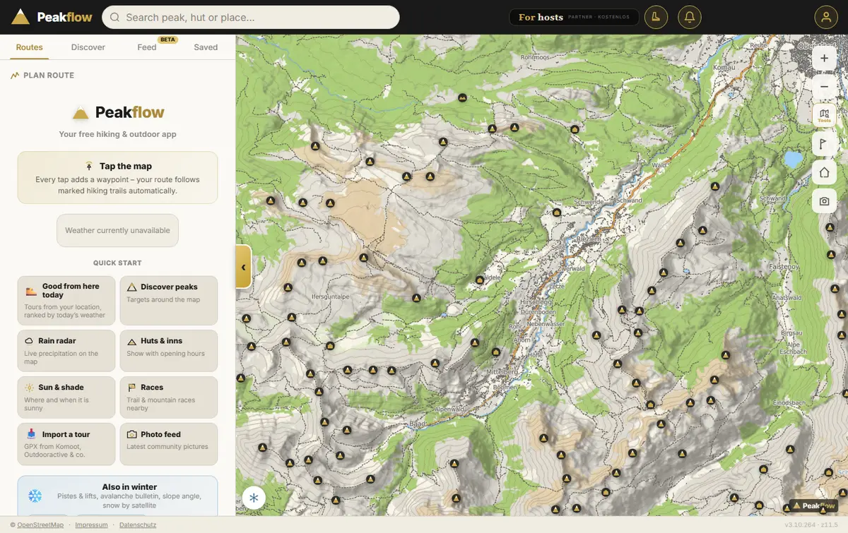
Each tap on the map adds a waypoint and the line snaps to marked paths. Choose your activity – hiking, trail running or cycling/MTB – and Peakflow works out distance, climbing and time to match. The route colour tells you the activity at a glance: yellow for hiking, pink for trail running, violet for cycling.
Short on ideas? The quick start tile “Good from here today” suggests tours from your location, ranked by today's weather and snow. “Discover peaks” lists destinations around the visible map, and “Sun & shade” shows where it will be sunny and when – handy on chilly autumn mornings or hot July afternoons.
Three activities, fitting paths
A hiking profile for mountain trails, trail running with its own pace and cycling or mountain biking on rideable ways.
More than 36,000 peaks
With descriptions and a reachability check, plus passes and huts as destinations on the map.
Rain radar and storm warnings
Live precipitation on the map and an early warning before an afternoon thunderstorm builds up.
Race calendar
Trail running, road running, mountain bike, ski & cross-country and triathlon – dates and courses nearby.
Voice navigation that keeps working offline
On the move, Peakflow leads you junction by junction. Directions are read by a natural-sounding voice; the audio snippets for your language are fetched when navigation starts and keep playing where there is no signal at all.
For valleys without reception, save offline maps in the app: pick an area, see the expected size, download. The “Offline maps” screen always shows what is stored and how much space it takes. If you have walked the route before, your earlier tour joins as a ghost runner so you know whether you are faster today.
Huts with opening hours, buses and cable cars
The nicest loop is no fun if the hut is closed for its rest day or the last bus has left. Peakflow shows places to eat with opening hours, bus stops with departure times and cable cars right on your route. Getting there by bus and lift is part of planning, with live timetables in many regions.
On top of that you get snow conditions, the cloud ceiling and reported trail closures, so you know before setting off whether the crossing is open – instead of finding out at the trailhead.
Bring your tours from komoot
If you have a planned or recorded tour as a GPX file, it opens in Peakflow within seconds. Taking your own data with you in a common format is a right under the GDPR (Article 20, data portability).
- Save the GPX file of your tour on your phone or computer.
- Open Peakflow and choose “Import a tour” in the quick start.
- Select the file – the route appears on the map, ready to follow, adjust or navigate.
Coming from Strava, Garmin Connect or Apple Health as well? Peakflow can read the entire data archive from those services in one go, so every activity lands on your profile with its map. The steps are in the archive import guide.
After the tour: feed, flows and Garmin
Share tours in the feed if you like – with photos, elevation profile and the weather while you were out. Other users can leave you Peaks, Peakflow's version of a like. Climbs between huts, cols and summits are scored as flows with their own leaderboards, and Garmin owners can add the data field “Peakflow Live” so tours arrive from the watch automatically.
Private stays private: set a tour to “only me”, and hide start, finish and heart rate from others in your profile.
Peakflow and komoot compared
The table only includes details that komoot publishes on its own website. Which app is right for you depends on where and how you head out.
| Feature | Peakflow | komoot (according to komoot) |
|---|---|---|
| Plan, navigate, record | free | free to use |
| Offline maps | free, focused on the Alps | one region free, worldwide with Premium |
| Weather for your tour | free, including storm warnings | weather along the route: Premium |
| Live tracking | free with the Garmin data field | Premium |
| 3D map | free (3D peak map) | Premium |
| Worldwide maps | no – focused on the Alps | Premium |
As of September 2026. Offers may change at any time. Sources: komoot.com/premium · komoot.com: Hiking App with Offline Maps
To be fair: Peakflow focuses on the Alps. If you plan trips all over the world, you will not find the same depth of data everywhere. Peakflow is an independent one-person project with no connection to komoot.
Frequently asked questions
Is Peakflow a free Komoot alternative?
Peakflow is free, with no subscription and no ads. Route planning, voice navigation, offline maps, weather and hut information all work without a paid tier, with a focus on the Alps.
Can I open my komoot tours in Peakflow?
Yes, if you have the tour as a GPX file. Choose “Import a tour” in Peakflow and select the file – the route appears on the map, ready to follow or navigate.
Does navigation work without mobile signal?
Yes. Save a map area as an offline map beforehand. Voice prompts are loaded when navigation starts and keep working in dead zones.
Can Peakflow plan bike and MTB routes?
Yes. Besides hiking and trail running there are profiles for cycling and mountain biking, and the route colour shows the activity.
Do I need an account?
Not for the map, route planning or the race calendar. The tour feed, flows, saved tours and archive import need a free account.
Is Peakflow affiliated with komoot?
No. Peakflow is an independent project and has no connection to komoot.
Plan your next outing now
Open the map, tap twice, done. In the browser or as an app for Android and iOS.